Conducting a Route Threat Assessment on Thailand’s Roads

Date: Friday, 22 December 2017
Topics: Physical Terrain | Crime | Infrastructure
EXECUTIVE SUMMARY
While roads in Thailand are quite developed and consist of several main highways and roads that can provide easy access around the country, road travel in Thailand can be severely affected by floods and the threat of vehicle accidents due to the behavior of road users. It is PROBABLE the period of highest threat is during the wet season from May to October/November as these conditions affect the majority of the country.
INTRODUCTION
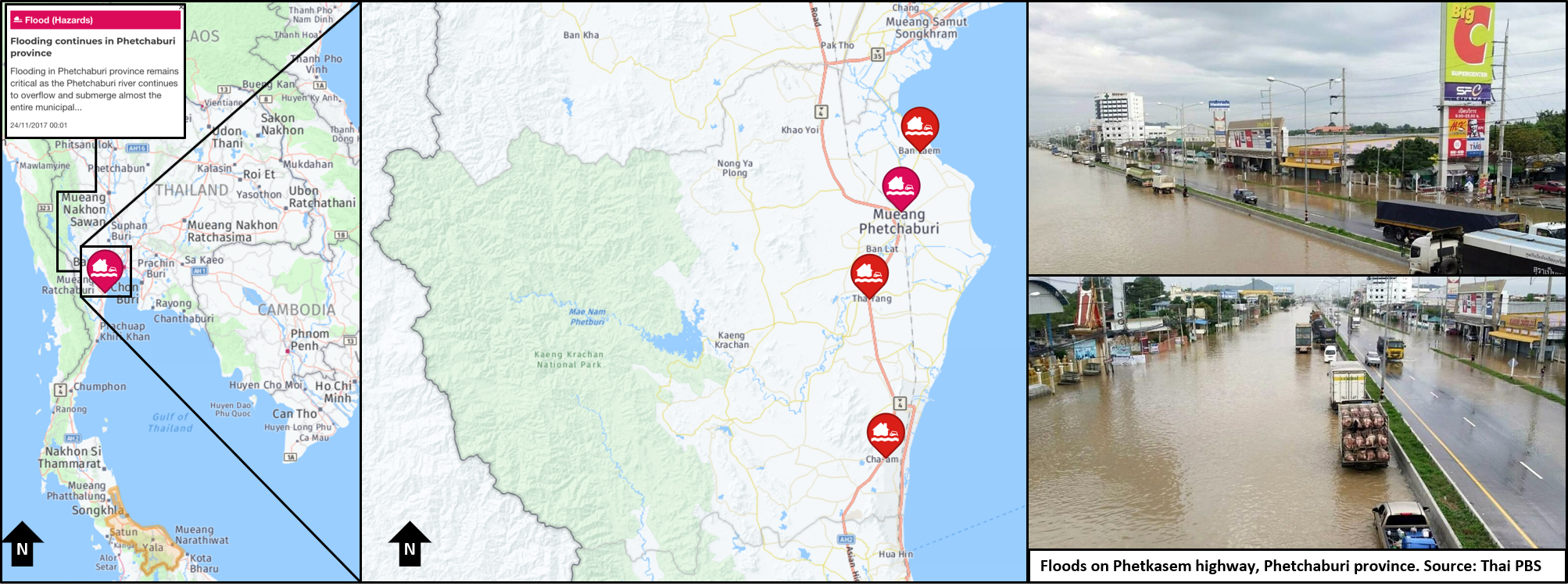
Reporting on the 24 NOV 2017 showed that continued flooding in Phetchaburi province caused the Phetchaburi river to overflow and submerge large areas in Mueang Phetchaburi, Ban Laem, Cha-am and Tha Yang districts. Sections of the Phetkasem Road, a main highway to the southern region, remained flooded and impassable for small vehicles, particularly on the inbound traffic lanes to Bangkok. Flood levels on the highway were between 40-60 centimetres, making the road impassable for small vehicles (McCabe and Harrington, 2017).
The flooding was caused by continuous rainfalls brought by depression “Kirogi,” which according to reports used to log the incident on the Intelligence Fusion platform caused the Phet Dam to discharge water to Phetchaburi River, making it break its banks. Highway police warned motorists to utilise two alternative routes for inbound traffic to and from and the South. For inbound traffic from the South to Bangkok (McCabe and Harrington, 2017).
COMMENT. Floods have been an ongoing hazard in Thailand. From May to October, floods from heavy rain and the subsequent requirement for dams to discharge water occurred frequently in the North, North-East and Central regions of Thailand. Since November, floods have become more prevalent in the South of the country, resulting in entire provinces being declared disaster areas with roads and other infrastructure being affected by rising water levels. (McCabe and Harrington, 2017, PRATTEN 2017j, PRATTEN 2017g, PRATTEN 2017i, PRATTEN 2017h, PRATTEN 2017b).
As shown in the imagery above, there are several smaller roads to the west of the Phetkasem highway. However, further South is Prachuap Khiri Khan province where the Myanmar border is in close proximity and forests reduce the available area for road traffic; creating a bottleneck in terms of physical terrain and national borders. The flooding and subsequent diversions would have thus extended the already existing bottle neck and affect road access between the South, Bangkok and areas further North and East in Thailand. COMMENT ENDS.
With all of the above in mind, this report aims to provide a route analysis product on roads in Thailand with a view to determine:
What are the road conditions in Thailand?What threats exist to drivers in Thailand?What capabilities exist to mitigate or respond to these threats?
1. WHAT ARE THE ROAD CONDITIONS IN THAILAND?
Quality of roads in Thailand are a good standard with the quality of roads at its highest in the major cities. The speed limit on the highway is 100 km/h (62 mph) or 120 km/h (75 mph) depending on the road. The “rush hour” in the morning occurs between 6am to 9am and from 4pm to 7pm. Based on the mapping below, there is a well-developed highway network connecting all major cities that are usually four-lane highways; the majority of these types of road are located in Bangkok. (Le Petit, 2016, Justlanded.com, 2017, Global Affairs Canada, 2017).
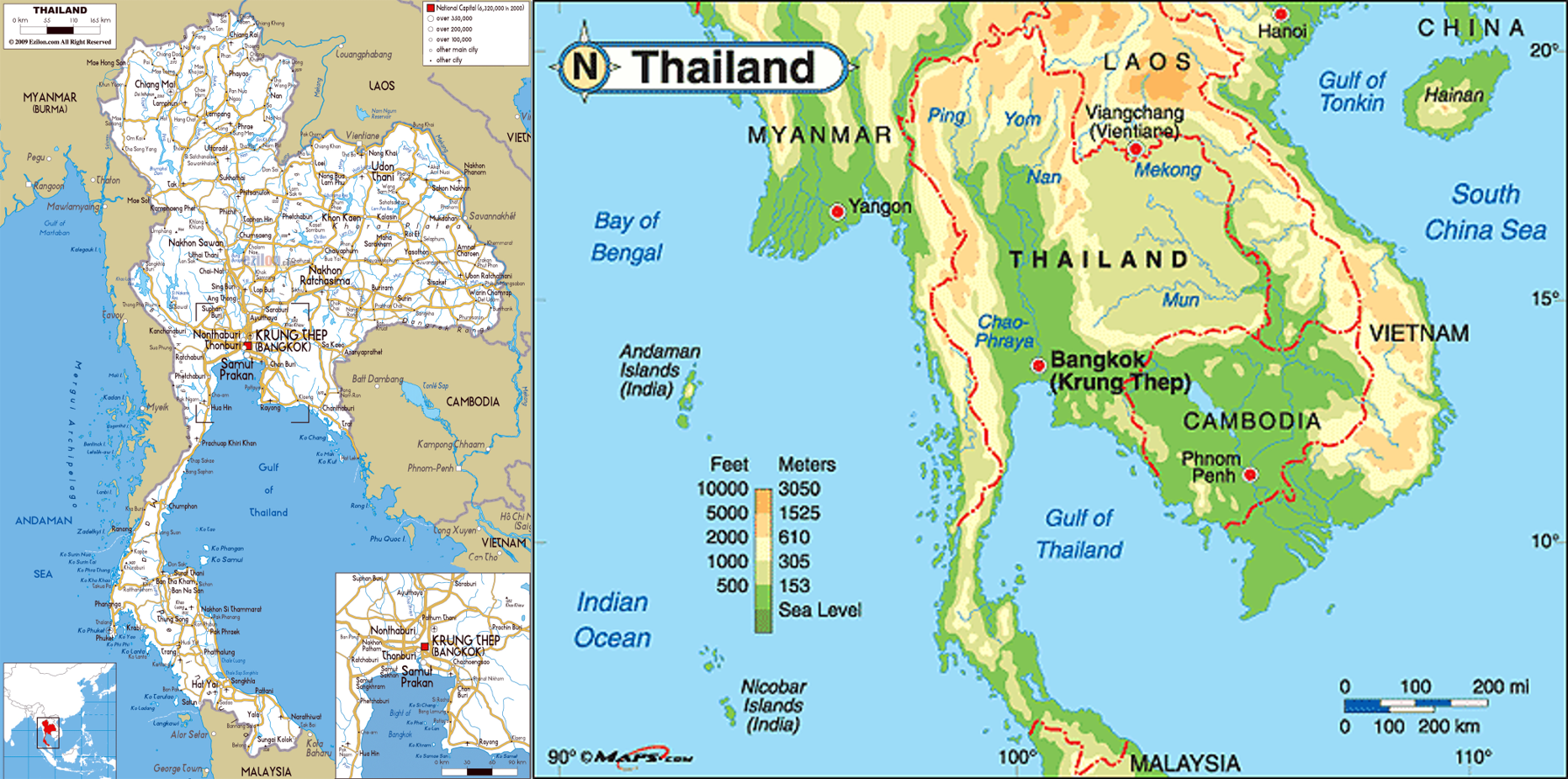
COMMENT. The imagery above does indeed support the quality of road infrastructure in Thailand. From Bangkok to the North there appear to be various major roads, mitigating the effects of one of these roads being unsuitable for use. However, from Bangkok down to Phang Nga and Surat Thani provinces, there appears to be only one major route; that route being the one affected by floods recently. After reaching Phang Nga/Surat Thani, the number of major roads increases for motorists (Le Petit, 2016).
Previous analysis conducted on Thailand’s physical terrain mentioned Thailand has specific natural features depending on the region in the country. As indicated in the map above (Hays, 2008, World Atlas, 2017, PRATTEN 2017a):
The North is mostly mountainous, making it the origin of streams and rivers in Thailand formed at the convergence the Ping, Wang, Yom, and Nan rivers. With its natural features of high mountains, steep river valleys and upland areas, summer storms occur quite often.The North-East is defined by the Khorat Plateau consisting of low hills and small lakes draining into the Mekong River system on its border with Laos. Geographical features of the region comprise the flatland in the centre, rugged hills to the west and the south.The Central region is a flood plain with the Chao Phraya River as the main water source. It’s surrounded by mountains and plateaus to the West, North and East. This river system drains about one third of Thailand, flowing for approximately 372 kilometres.The South features the Isthmus of Kra which appears to rise no higher than 610m above sea level; narrowly dividing the Andaman Sea and Indian Ocean to its West and the Gulf of Thailand to its East. Most areas are flat, with rolling and mountainous terrain made up of major mountains such as the Tanaosi mountains to the west, lying from Kanchanaburi in the central region down to Ranong, as well as the Nakhon Si Thammarat mountains in the middle, and the Phuket mountains along the west coast to Phuket Island, with the Tanaosi and the Sankala Khiri forming the boundary with Malaysia. COMMENT ENDS.
2. WHAT THREATS EXIST TO DRIVERS IN THAILAND?
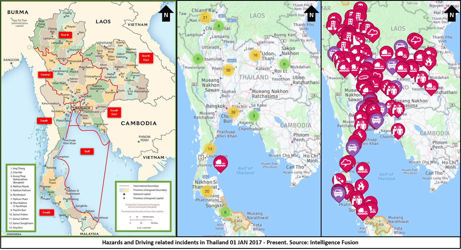
Based on above mentioned incident and incidents plotted on the Intelligence Fusion platform, a major threat to drivers in Thailand is from weather conditions and their impact on Thailand’s physical terrain; affecting roads as a result. The imagery below shows all hazard incidents plotted since the beginning of 2017 which have affected roads and road travel.
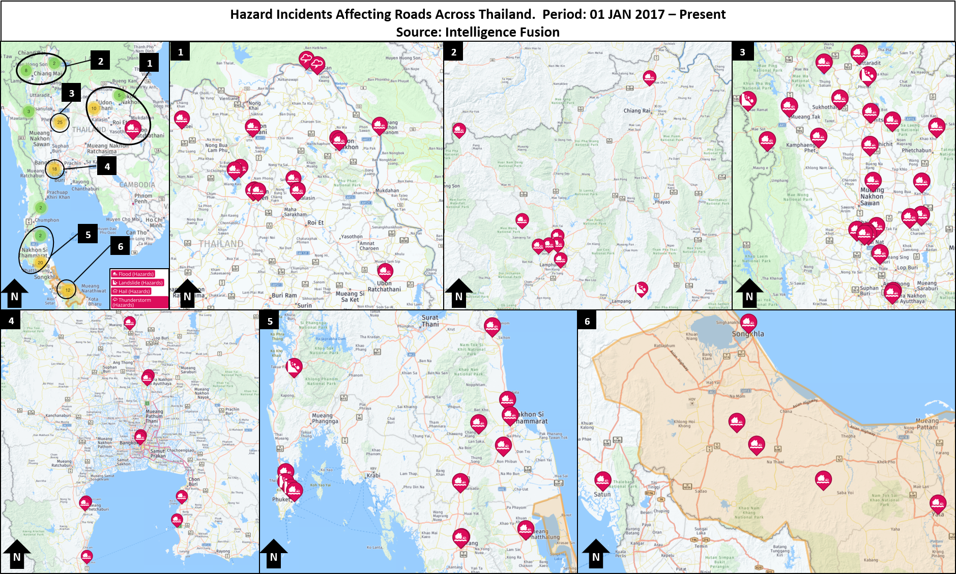
As shown above, the areas affected the most by hazards such as floods have been the Central, North-Eastern and Southern parts of the country. With the exception of the Southern provinces, the Central and North-Eastern parts of Thailand saw the majority of the floods during the wet season running from May to October/November this year. These parts of Thailand were consistently hit by heavy rain, causing rivers and dams to overflow and flood many provinces in these areas. As for the South, Phuket has been flooded a number of times during the wet season in the North but is also experiencing some of the heavy rain the remainder of the Southern provinces of Nakhon Si Thammarat, Surat Thani, Phattalung, Songkhla, Yala, Narathiwat, Pattani, Satun and Trang provinces are currently experiencing. Many of these provinces remain flooded with damages to roads, rail and at one point has closed Nakhon Si Thammarat Airport (PRATTEN 2017d, PRATTEN 2017f, PRATTEN 2017h, PRATTEN 2017b, PRATTEN 2017c, PRATTEN 2017e).
COMMENT. Based on earlier imagery of Thailand’s road network, many of these areas which have been heavily affected by floods also contain the majority of the numerous roads and highways. During periods of heavy rain in Thailand – from May to October/November for Bangkok and further North and what appears to be from November and onwards for the South at the moment – These roads would appear to be directly exposed to the damage which can be caused by monsoon conditions and for elevated areas; the threat of landslides which are an indirect consequence of heavy rain and flooding. While the numerous highways and roads would mitigate the effect of one or multiple roads being impacted, a great deal of the highways and roads are exposed to harsh weather conditions; creating a risk they could all be hit. COMMENT ENDS.
In addition to the impact of weather conditions comes a type of human error; driver fatigue, reckless driving such as speeding, reckless passing, and failure to obey other traffic laws are common in all regions of Thailand. Some drivers move illegally against the traffic, which moves on the left. Commercial drivers commonly consume alcohol, amphetamines, and other stimulants. These threats on the road are a common feature in Bangkok, Koh Samui, Pattaya, Chiang Mai and Phuket. Such conduct by road users in Thailand has earned the country a reputation for it being only less lethal than Libya with a road mortality rate above its South-East Asian neighbours; whose road infrastructure is much poorer. (The Economist, 2016, Justlanded.com, 2017, Bureau of Consular Affairs, 2017) (Global Affairs Canada, 2017).
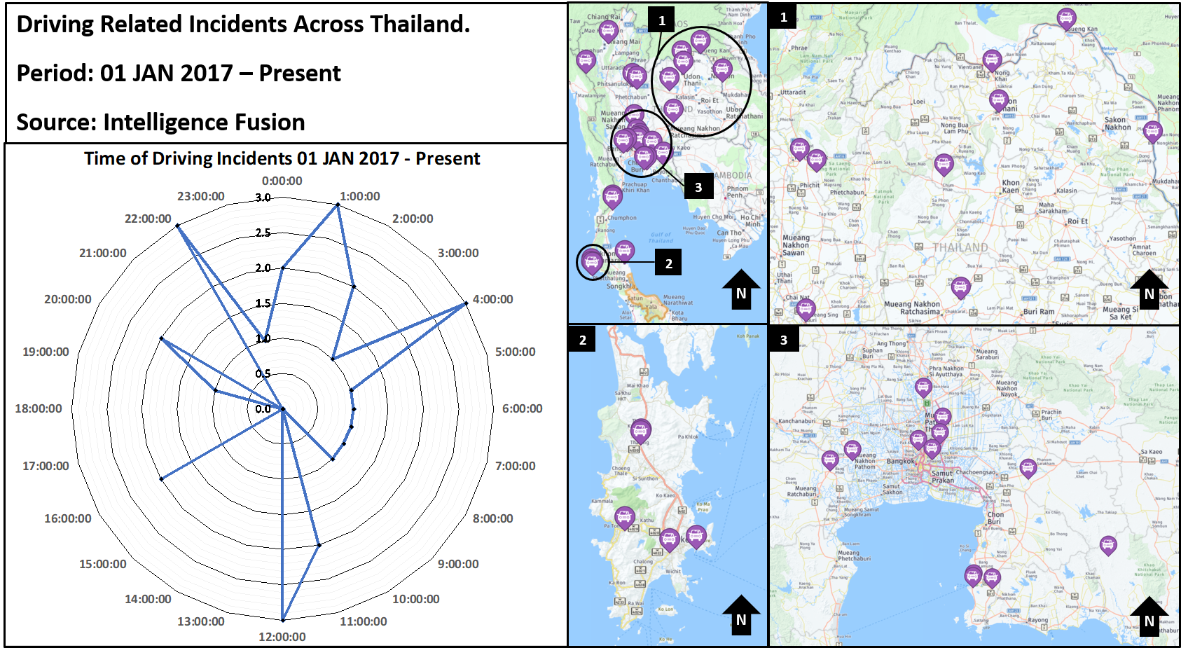
COMMENT. The above imagery shows all driving offences plotted on recorded on the Intelligence Fusion platform from 01 JAN 2017 – Present. Among the areas where driving offences appear to be concentrated are Bangkok and Pattaya, the North-Eastern areas from Nakhon Ratchasima province up to the border areas of Sakon Nakhon, Nong Khai and Bueng Khan and on the island of Phuket. Examination of these incidents has found the majority of incidents have been due to driver fatigue but there have been a few incidents of reckless driving and drivers under the influence of illicit substances. The majority of incidents being driver fatigue warranted closer examination of the times the incidents occurred. As depicted in the radar chart above, the incidents so far have shown that most incidents of vehicle accidents have been occurring between 22:00-04:00 hours (McCabe and Harrington, 2017). It could be said with confidence the threat of being in an accident with another vehicle in Thailand is at its highest between 22:00-04:00 hours at night, particularly in the areas shown above and mentioned beforehand. COMMENT ENDS.
3. WHAT CAPABILITIES EXIST TO MITIGATE OR RESPOND TO THESE THREATS?
There are three capabilities in country which can mitigate the threats posed by the above hazards. The first is the information provided by the foreign ministries in country that can provide general information on the above types of hazards and how to avoid them. There are five in particular that also provide the means for a traveller to Thailand to register their details in the event they are caught up in either a road accident or floods while using the roads in Thailand – provided the traveller is of course a citizen of that country. These foreign ministries are the Australian, United States, Canadian, British and New Zeeland Foreign Ministries (Bureau of Consular Affairs, 2017, Department of Foreign Affairs and Trade, 2017, Foreign and Commonwealth Office, 2017, Global Affairs Canada, 2017, New Zealand Ministry of Foreign Affairs and Trade, 2017).
Another major factor to mitigate the threats on Thailand’s roads is to ensure one can be contacted or contact a relevant party for assistance through the use of a mobile phone. Examination of mobile phone coverage in Thailand has revealed there are at least 6 telecommunication providers in Thailand; their names and the coverage they provide are shown in the imagery below.
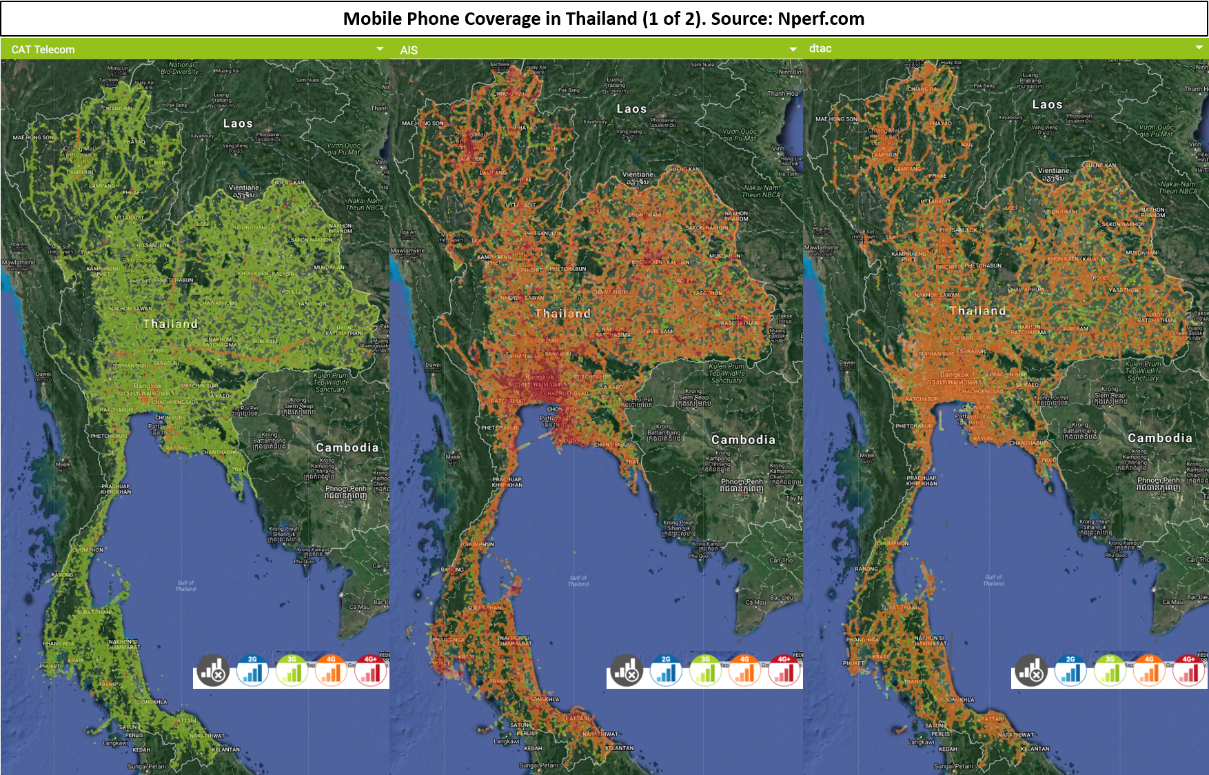
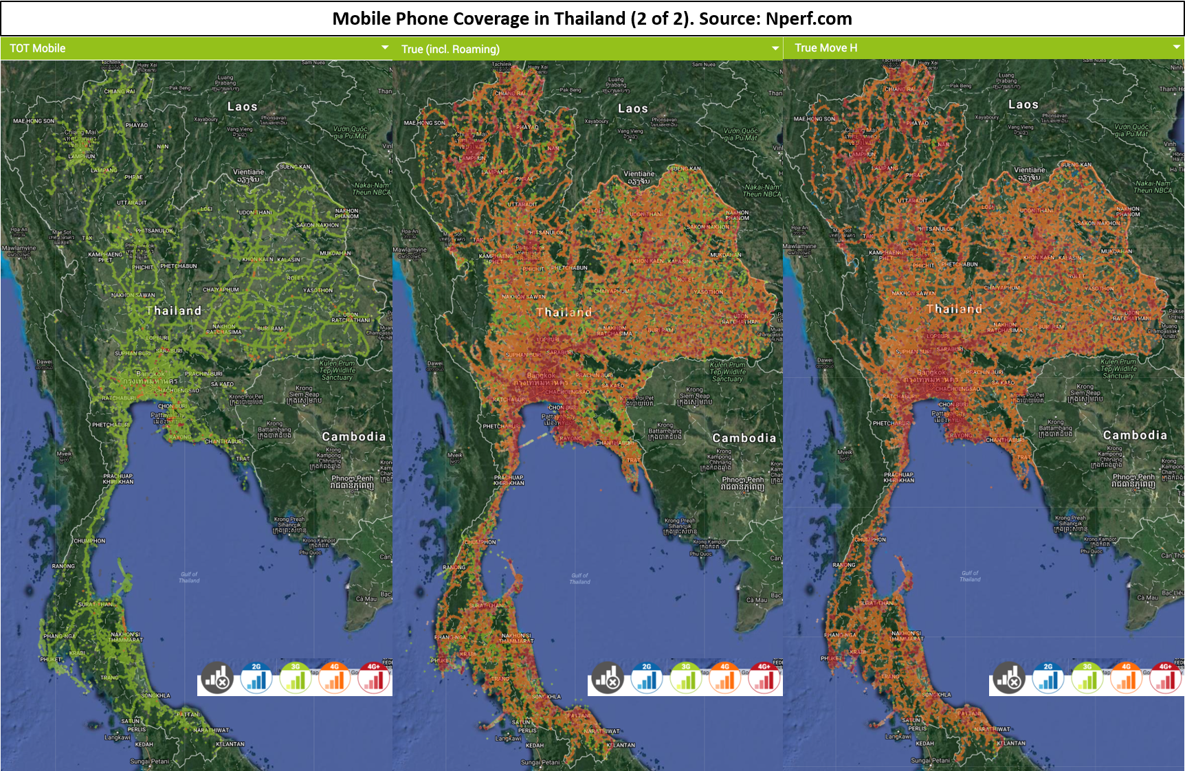
COMMENT. The above imagery indicates four of the six service providers – True, True Move H, AIS and DTAC – provide a high level of coverage around Thailand but also provide up to 4G or 4G+ coverage; enabling the ability to use smart phones to track the latest information on road conditions (NPerf, 2017). However, while the above coverage does appear to cover most of the country, factors such as black spots, heavy network use and signal towers being affected by weather conditions. COMMENT ENDS.
The third factor identified for mitigating the threats to road travel in Thailand is the use of alternative transport. There are numerous airports around Thailand with multiple points of international entry/exit and a vast number of domestic airports around the country shown in the imagery below (CAPA Centre For Aviation, 2017). These numerous airports would provide an effective alternative to road travel.
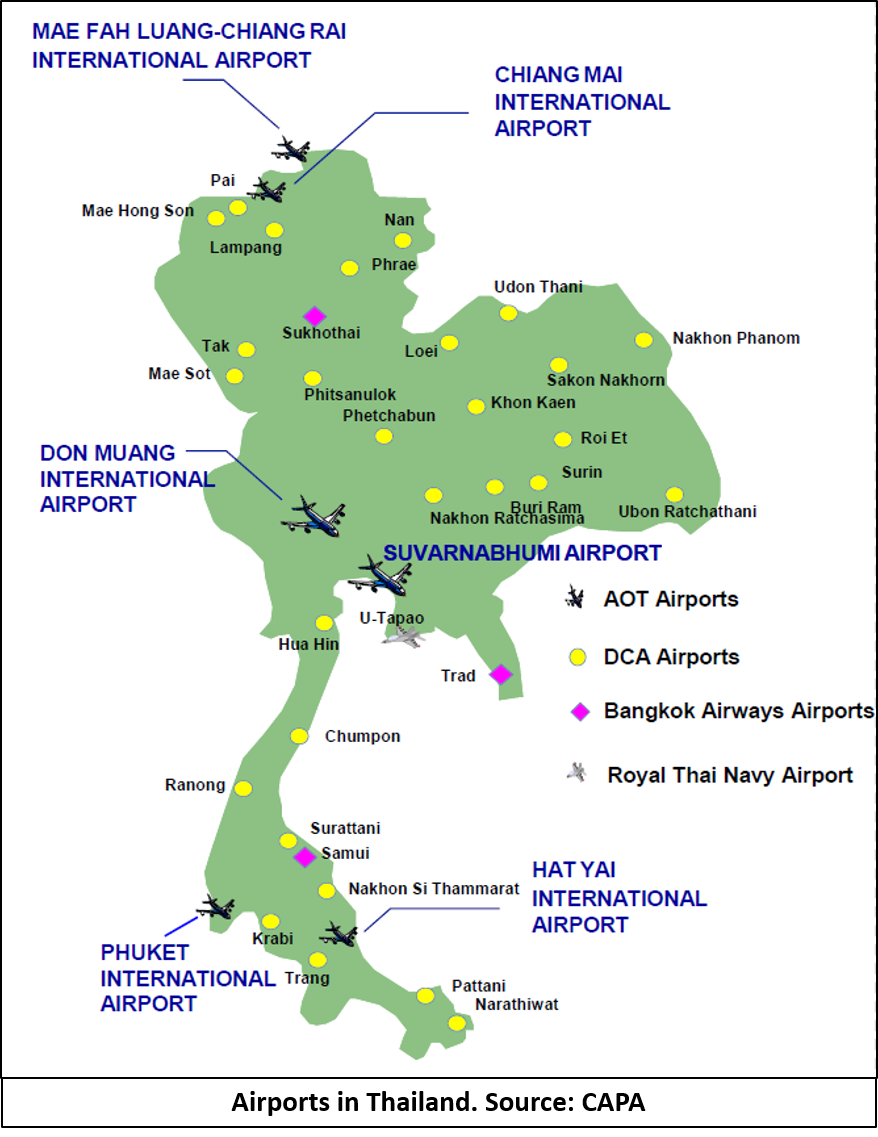
COMMENT. It needs to be noted though, during the floods which have been occurring there have been two airports closed down due to their runways being flooded – Nakhon Si Thammarat in the South and Sakon Nakhon Airport in the North East (McCabe and Harrington, 2017). Both airports though have several other nearby and neither are international airports. COMMENT ENDS.
ASSESSMENT

While roads in Thailand are quite developed and consist of several main highways and roads that can provide easy access around the country, road travel in Thailand can be severely affected by floods and the threat of vehicle accidents due to the behavior of road users. It is PROBABLE the period of highest threat is during the wet season from May to October/November as these conditions affect the majority of the country.
However, travelling throughout the country can PROBABLY be mitigated effectively through:
Avoiding driving in high traffic areas such as Bangkok, Koh Samui, Pattaya, Chiang Mai and Phuket. Particularly at night as it is PROBABLE that the risk of being in a vehicle accident is at its highest between the hours of 22:00-04:00 as well as the “rush hour” periods.Ensuring the relevant foreign ministry – depending on the traveler’s nationality – is aware of the traveler’s intent to go to Thailand and has the relevant details and contact information.During the months of May-October/November, it is PROBABLE the North-East, Central and POSSIBLY Bangkok areas will be subject to continuous, heavy rain causing rivers and dams to overflow; resulting in floods and their subsequent effect on road access as well as creating a risk of landslides in mountainous areas. At this point in time, the South will PROBABLY remain heavily flooded. With these conditions, travelling to or through these parts of Thailand would POSSIBLY be better done by air. However, floods and heavy rain can POSSIBLY affect domestic airport access.During any travel through Thailand – especially by road – mobile phone coverage and access to information on road conditions will PROBABLY be best achieved through a mobile phone service through True, True Move H, AIS and DTAC. These companies appear to provide the best capabilities in mobile phone coverage and services provided. However, it is POSSIBLE that a service through two companies may be necessary in order to mitigate the risks of black spots or areas where coverage is low for a particular company. This will especially be necessary if travelling throughout the country is to be done.
References
BUREAU OF CONSULAR AFFAIRS. 2017. Thailand [Online]. Wahington D.C.: US Department of State. Available: https://travel.state.gov/content/passports/en/country/thailand.html [Accessed 20 December 2017].
CAPA CENTRE FOR AVIATION. 2017. Bangkok Airways IPO: Proving There Is Still Room For An Independent Full-Service Short-Haul Airline [Online]. Sydney: CAPA Centre For Aviation,. Available: https://centreforaviation.com/insights/analysis/bangkok-airways-ipo-proving-there-is-still-room-for-an-independent-full-service-short-haul-airline-113808 [Accessed 20 December 2017].
DEPARTMENT OF FOREIGN AFFAIRS AND TRADE. 2017. Thailand [Online]. Canberra: Department of Foreign Affairs and Trade,. Available: http://smartraveller.gov.au/countries/asia/south-east/pages/thailand.aspx [Accessed 20 December 2017].
FOREIGN AND COMMONWEALTH OFFICE. 2017. Thailand [Online]. London: Foreign and Commonwelath Office. Available: https://www.gov.uk/foreign-travel-advice/thailand [Accessed 20 December 2017].
GLOBAL AFFAIRS CANADA. 2017. Thailand [Online]. Ottawa: Global Affairs Canada, . Available: https://travel.gc.ca/destinations/thailand [Accessed 20 December 2017].
HAYS, J. 2008. Geography Of Thailand [Online]. Saga: Facts and Details.com. Available: http://factsanddetails.com/southeast-asia/Thailand/sub5_8h/entry-3323.html [Accessed 03 September 2017].
JUSTLANDED.COM. 2017. Driving in Thailand – Street Conditions, Traffic and Rush Hour [Online]. Madrid: justlanded.com. Available: https://www.justlanded.com/english/Thailand/Thailand-Guide/Travel-Leisure/Driving-in-Thailand [Accessed 10 December 2017].
LE PETIT, P. 2016. Map Room [Online]. Thailand: Asiaphotos.org. Available: http://patricklepetit.jalbum.net/01-THAILAND/Maps/index.html – large_detailed_road_map_of_thailand.jpg [Accessed 10 December 2017].
MCCABE, M. & HARRINGTON, D. 2017. Intelligence Fusion Platform [Online]. Durham: Ambix. Available: https://www.intelligencefusion.co.uk/ [Accessed 17 December 2017].
NEW ZEALAND MINISTRY OF FOREIGN AFFAIRS AND TRADE. 2017. Thailand [Online]. Wellington: New Zealand Ministry of Foreign Affairs and Trade. Available: https://www.safetravel.govt.nz/thailand [Accessed 01 July 2017].
NPERF. 2017. 2G/3G/4G Coverage Map [Online]. France: nPerf. Available: https://www.nperf.com/en/map/TH/-/1885.dtac/signal/ [Accessed 20 December 2017].
NPERF. 2017. 2G/3G/4G Coverage Map [Online]. France: nPerf. Available: https://www.nperf.com/en/map/TH/-/1885.dtac/signal/ [Accessed 20 December 2017].
PRATTEN M. 2017a. Fortnightly Snapshot: Thailand’s Flood Hazards. Intelligence Fusion [Online]. Available: https://www.intelligencefusion.co.uk/single-post/2017/09/04/Fortnightly-Snapshot-Thailands-Flood-Hazards [Accessed 08 September 2017].
PRATTEN M. 2017b. Thailand Weekly Intelligence Report – 04 December 2017. Thailand [Online], 04 December 2017. Available: https://www.intelligencefusion.co.uk/single-post/2017/12/04/Thailand-Weekly-Intelligence-Report [Accessed 11 December 2017].
PRATTEN M. 2017c. Thailand Weekly Intelligence Report – 14 December 2017. Thailand [Online], 14 December 2017. Available: https://www.intelligencefusion.co.uk/single-post/2017/12/14/Thailand-Weekly-Intelligence-Report [Accessed 17 December 2017].
PRATTEN M. 2017d. Thailand Weekly Intelligence Report – 14 November 2017. Thailand [Online], 12 November 2017. Available: https://www.intelligencefusion.co.uk/single-post/2017/11/14/Thailand-Weekly-Intelligence-Report [Accessed 19 November 2017].
PRATTEN M. 2017e. Thailand Weekly Intelligence Report – 19 December 2017. Thailand [Online], 19 December 2017. Available: https://www.intelligencefusion.co.uk/single-post/2017/12/19/Thailand-Weekly-Intelligence-Report [Accessed 20 December 2017].
PRATTEN M. 2017f. Thailand Weekly Intelligence Report – 19 November 2017. Thailand [Online], 19 November 2017. Available: https://www.intelligencefusion.co.uk/single-post/2017/11/21/Thailand-Weekly-Intelligence-Report [Accessed 25 November 2017].
PRATTEN M. 2017g. Thailand Weekly Intelligence Report – 22 October 2017. Thailand [Online], 22 October 2017. Available: https://www.intelligencefusion.co.uk/single-post/2017/10/22/Thailand-Weekly-Intelligence-Report [Accessed 30 October 2017].
PRATTEN M. 2017h. Thailand Weekly Intelligence Report – 27 November 2017. Thailand [Online], 27 November 2017. Available: https://www.intelligencefusion.co.uk/single-post/2017/11/27/Thailand-Weekly-Intelligence-Report [Accessed 03 December 2017].
PRATTEN M. 2017i. Thailand Weekly Intelligence Report – 31October 2017. Thailand [Online], 31 October 2017. Available: https://www.intelligencefusion.co.uk/single-post/2017/10/31/Thailand-Weekly-Intelligence-Report [Accessed 05 November 2017].
PRATTEN M. 2017j. Weekly Intelligence Report: Monitoring in Thailand – 18 September 2017. Thailand [Online], 16 September 2017. Available: https://www.intelligencefusion.co.uk/single-post/2017/09/17/Weekly-Intelligence-Report-Monitoring-in-Thailand [Accessed 25 November 2017].
THE ECONOMIST. 2016. Thailand’s Deadly Roads: Look Both Ways. The Economist [Online]. Available: https://www.economist.com/news/asia/21697029-another-bout-hand-wringing-over-countrys-lethal-roads-look-both-ways [Accessed 10 December 2017].
WORLD ATLAS. 2017. Thailand Geography [Online]. Quebec: World Atlas. Available: http://www.worldatlas.com/webimage/countrys/asia/thailand/thland.htm [Accessed 03 September 2017].
About the author